


MapItFast- Field-based Mapping
Description of MapItFast- Field-based Mapping
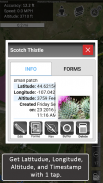
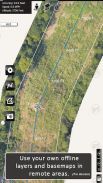
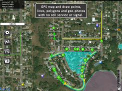
MapItFast transforms your phone or tablet into a powerful field mapping and data collection tool—even when you’re off the grid. Quickly create points, lines, polygons, and geophotos with a single tap with no GIS expertise required.
Key Free Features:
• Tap the icon to map objects instantly via GPS, or long-press to draw them by hand.
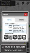
• Capture geophotos, measure distances, and calculate areas in real time.
• Pause or resume GPS tracking at any moment, and work on multiple lines or polygons simultaneously.
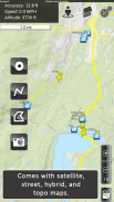
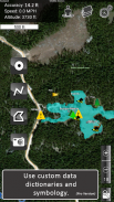
• Choose from aerial, street, and topo basemaps for a clear reference in any environment.
MapItFast Professional
Upgrade to the paid version for enterprise-level functionality and organize your work into projects, add custom basemaps and digital forms, and automatically sync everything to your private cloud account. MapItFast Professional includes web-based mapping features that seamlessly synchronize projects and user data across Android and iOS devices, fostering collaboration on unlimited projects and enabling custom form creation.
Key Paid Features
• Cloud-Based Sync: Access maps and data across devices and on the web.
• Real-Time Collaboration: A web portal shows projects, users, and updates as they happen.
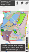
• Custom Maps & Symbology: Easily load and distribute your own mapping styles.
• Integrated Forms: Add attributes directly to map objects in the app.
• Symbol Triggers: Auto-update map symbols as forms are completed.
• Custom Reports: Generate branded PDF or email reports with maps, photos, and form data.
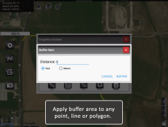
• Advanced GIS Tools: Work with buffers, splits, donuts, and more.
• Flexible Data Management: Search, sort, edit, copy, and move objects across projects.
• Shapefile Import/Export: Bring in shapefiles or export to KMZ, SHP, and GPX.
• Two-Way Sync: Real-time updates between field devices and your online account.
• User Permissions: Control project access and roles at individual or group levels.
Extend Your Capabilities
Enhance MapItFast’s capabilities with AgTerra’s hardware devices for real-time equipment activity tracking and mapping:
• SprayLogger: Automate pesticide application data logging and generate detailed reports.
• SnapMapper: Quickly create points and lines in MapItFast from any mechanical switch.
MapItFast is Perfect for Agriculture and Natural Resource Entities Performing:
• Vegetation management & pesticide reporting
• Mosquito trap inspection & vector control
• Field surveys & inspections
• Crop scouting
• Wildfire/disaster response & prevention
• Rangeland & water management
• Utilities & forestry operations
Simplify your field mapping process and streamline data management across your team or organization. Learn more about all our solutions at www.agterra.com.
MapItFast- Field-based Mapping - Version 8.0.8 Build 03.03.2025a
(23-03-2025)MapItFast- Field-based Mapping - APK Information
APK Version: 8.0.8 Build 03.03.2025aPackage: com.agterra.MapItFastLatest Version of MapItFast- Field-based Mapping
Other versions


 4.28
4.28


Apps in the same category

You may also like...


